Plainfield Road Corridor Study
Thank you for visiting the Plainfield Road Corridor Study webpage.
The Cook County Department of Transportation and Highways (DoTH) is committed to ensuring that those who live and work in the County are part of our planning and design process.
Email ImprovePlainfieldRoad@gmail.com to request to join the mailing list to stay up to date on the Plainfield Road Project.
PUBLIC INFORMATION OPEN HOUSE
DoTH hosted an in person Public Information Open House for the Plainfield Road Corridor Study at Highlands Elementary School Aug. 4, 2025, from 5:30 to 7 p.m. Thank you to everyone who attended and participated in the open house.
The open house included a presentation on the study, public outreach, existing conditions, proposed improvements and next steps. Over 125 participants attended the Public Information Open House, including:
- More than 110 members of the public
- Municipal representatives from the Villages of Burr Ridge, Indian Head Park and La Grange, the Township of Lyons and the City of Countryside, among others
- Pleasantview Fire Protection District
- The Metropolitan Water Reclamation District of Greater Chicago
Materials displayed at the open house and included in the newsletter sent to attendees, stakeholders and individuals on the project mailing list are available for viewing via the links below.
Public Information Open House materials:
If you have any questions about the open house or the study, please contact the project team at ImprovePlainfieldRoad@gmail.com.
For media inquiries, please contact:
Natalia Derevyanny, Natalia.Derevyanny@cookcountyil.gov and Meaghan Johnson, Meaghan.Johnson@cookcountyil.gov
PROJECT OVERVIEW
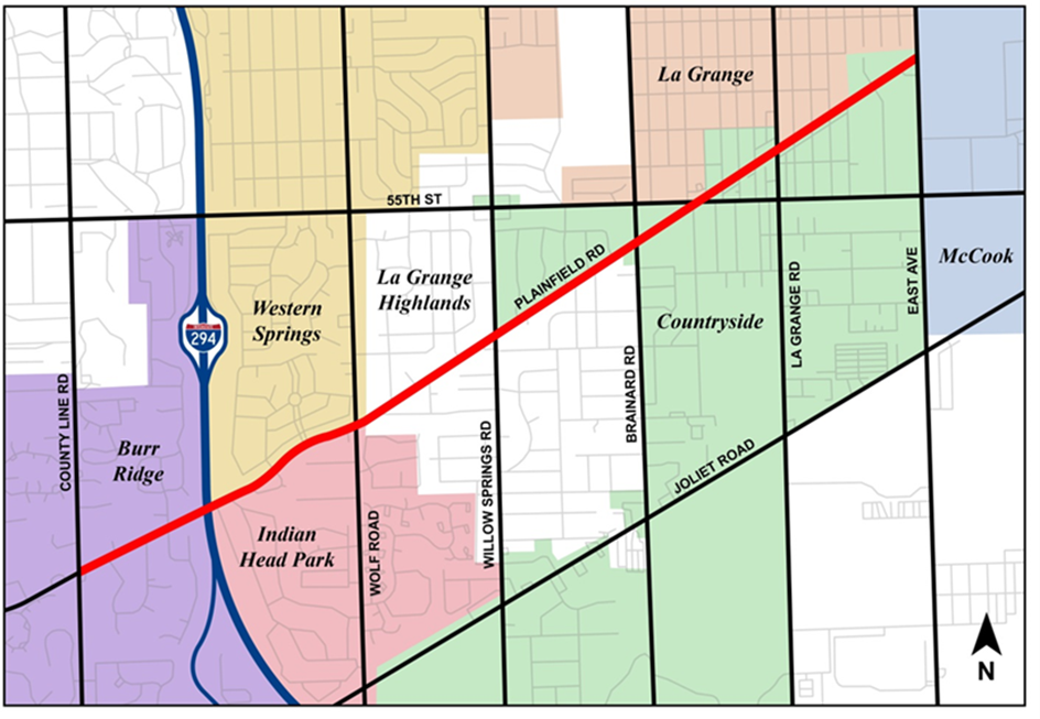
DoTH is proposing improvements to Plainfield Road from County Line Road to East Avenue. This 3.5-mile corridor is vital, serving an average of 14,000 vehicles per day. The corridor is home to a variety of commercial and industrial centers, recreational facilities, residential areas, places of worship and schools. It extends through the Villages of Burr Ridge, Western Springs, Indian Head Park, La Grange and McCook, the Township of Lyons and the City of Countryside.
All pavement sections throughout the corridor have reached the end of their useful service life and need full-depth reconstruction. While portions of the corridor that have been widened and resurfaced over the years, the subbase and subgrade of the pavement are original and were installed more than 60 years ago.
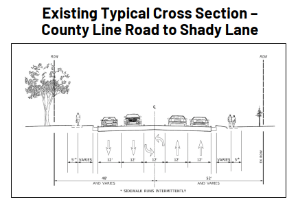
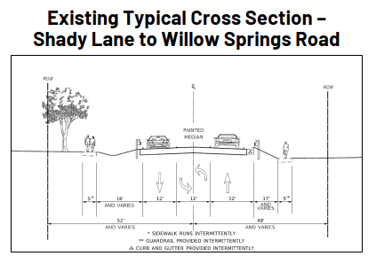
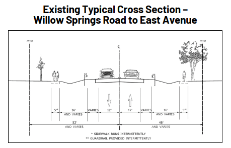
The three typical cross sections shown in the graphics below depict the existing layout of the roadway.
At the west end of the project, between County Line Road and Shady Lane, Plainfield Road is a five-lane section with two through lanes in each direction and a center median or left turn lane. This section includes curb and gutter in addition to sidewalk in isolated locations.
To the east, the section of Plainfield Road between Shady Lane and Willow Springs Road generally consists of a three-lane section with intermittent sidewalk, guardrail and curb and gutter.
East of Willow Springs Road, most of the route is a rural cross section with narrow shoulders and ditches. In this section, curb and gutter is only found near the major intersections, except for East Avenue. Existing sidewalks and guardrails are also present at limited locations within this segment of Plainfield Road.
The proposed improvements include:
- Full depth pavement reconstruction
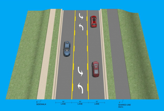
- One 11-foot through lane in each direction throughout the corridor
- Two 11-foot through lanes in each direction at the County Line Road intersection
- One 11-foot flush center median/two-way left turn lane to provide additional separation between the opposing traffic lanes and safe storage for left-turning vehicles
- Exclusive left and right turn lanes at the intersections of Plainfield Road at County Line Road, Wolf Road, Brainard Avenue and East Avenue
- New 5-foot sidewalk on the north side of Plainfield Road
- New 8-foot shared-use path on the south side of Plainfield Road
- Continuous curb and gutter throughout the corridor with new storm sewers
- Traffic signal modernization at the intersections of Plainfield Road at County Line Road, Wolf Road, Willow Springs Road, Brainard Avenue, 55th Street, La Grange Road and East Avenue
- New pedestrian crosswalks, push buttons with countdown timers and ADA compliant ramps
- Pedestrian refuge islands at three crossing locations on Burr Oak Drive, Howard Avenue and between Edgewood Avenue and Sunset Avenue
- Rectangular Rapid Flashing Beacons at the intersections of Plainfield Road at Garywood Drive/Manor Drive, Burr Oak Drive, Howard Avenue, Laurel Avenue and 8th Avenue
Proposed Roadway Configuration
- Improved roadway conditions
- Increased safety for vehicles, pedestrians and bicyclists
- Drainage improvements to prevent roadway flooding
- Intersection improvements to enhance traffic and safety operations
- Increased connectivity for bicyclists and pedestrians
- Improved sidewalk conditions
- Maintain and modernize what already exists
- Promote equal access to opportunities
- Prioritize transit and other transportation alternatives
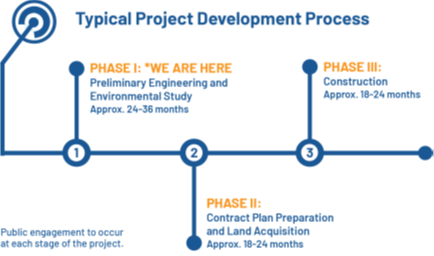
The preliminary engineering (Phase I) portion of the project is nearing completion. Subsequent phases of the project will be implemented over a multi-year period. The detailed engineering design (Phase II) for this project, along with required property acquisition, is scheduled to begin in early 2027 at the first segment of the project from west of Willow Spring Road to East Avenue. Construction (Phase III) is scheduled to start as early as 2029-2030, pending final design, land acquisition completion and funding availability.
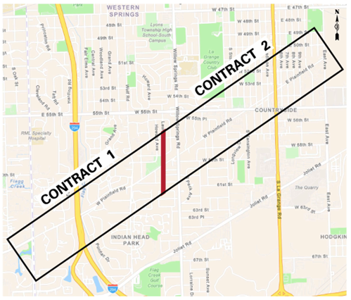
The proposed improvements are expected to be delivered through multiple-phased contracts to better manage construction logistics and funding availability. Contract 1 is expected to address the segment from County Line Road to west of Willow Springs Road. Contract 2 is expected to address the segment from west of Willow Springs Road to East Avenue. DoTH anticipates Contract 2 will advance to construction first.
To minimize impacts on local travel, DoTH plans to maintain at least one lane of traffic in each direction along Plainfield Road throughout construction. Access to all properties along the corridor will be maintained during construction.